-
 Call Now ! 7905582725
 -
 Email Now Help@makerspacekanpur.com
The AI Thinker GP-02 is a GNSS (GPS) module, designed to work with satellite navigation systems to provide:
Real-time location data (latitude, longitude)
Speed
Altitude
Time (UTC)
and more
It supports multiple satellite constellations:
GPS (USA)
GLONASS (Russia)
Galileo (EU)
BeiDou (China)
It communicates using UART (Serial) and is ideal for ESP32, Arduino, STM32, etc.
| Feature | Detail |
|---|---|
| Communication | UART (TX/RX) |
| Protocol | NMEA0183 |
| Baud Rate | 9600 bps (default) |
| Voltage | 3.3V logic and power |
| Satellite support | GPS, GLONASS, BDS, Galileo |
| Accuracy | ~2.5m |
| Update Rate | 1Hz (default), can be increased |
| GP-02 Pin | Function |
|---|---|
| VCC | 3.3V |
| GND | Ground |
| TX | Serial TX (data from GPS to ESP32) |
| RX | Serial RX (data from ESP32 to GPS) |
🧠 Note: You only need TX → RX and VCC/GND for location data reading.
Use SoftwareSerial alternative like HardwareSerial in ESP32:
| GP-02 | ESP32 |
|---|---|
| VCC | 3.3V |
| GND | GND |
| TX | GPIO 16 (RX of ESP32) |
| RX | GPIO 17 (TX of ESP32) |
You can use any available hardware UART (ESP32 has 3 UARTs: Serial0, Serial1, Serial2)
We’ll use the TinyGPSPlus library to parse GPS data:
Go to Arduino IDE:
Sketch > Include Library > Manage Libraries
Install TinyGPSPlus
| Project | Description |
|---|---|
| 📍 GPS Tracker | Real-time location tracking via GSM/LoRa/WiFi |
| 🚴 Bike Speedometer | Get speed, distance, and log path |
| 🛰️ IoT Location Logger | Store location logs in SD card or send to server |
| 🚗 Geo-fencing | Trigger actions based on location boundaries |
| 🧭 Navigation Device | Portable handheld GPS tool with OLED display |
Must be outdoors or near a window for best signal.
Cold start may take 30–60 seconds for the first lock.
Use a small GPS patch antenna for better reception if available.
HOW TO OPERATE


As per official documentation Step by step process for pico program run after power on:Save your pyt...

ESP32 Board are so popular? Mainly because of the following featuresLow-costBluetoothWiFiLow PowerDu...

Node MCU ESP8266 Board are so popular? Mainly because of the following features.Its true Arduino Kil...

🔧 Basic IntroductionL298N is a dual H-Bridge motor driver IC that allows controlling the direction...

🔧 Components Needed:ComponentQuantityESP32 Dev Board1L298N Motor Driver Module1DC Gear Motors (TT o...

The ADXL335 is a small, thin, low-power 3-axis analog accelerometer manufactured by Analog Devices....

🧠 What is an Ultrasonic Sensor?An ultrasonic sensor is a device that uses sound waves to detect how...

📌 What is the DHT11 Sensor?The DHT11 is a basic, low-cost digital temperature and humidity sensor....

🔥 FIRE BOT – Bluetooth Controlled Fire Extinguisher RobotWelcome to the FIRE BOT project! This robo...

BMP180 Sensor: Digital Barometric Pressure SensorThe BMP180 is a digital barometric pressure sensor...
🔧 1. Hardware Overview: 1.8" TFT DisplayMost 1.8" TFT modules are based on the ST7735 driver and co...

The SSD1306 is a popular controller used in OLED (Organic Light Emitting Diode) displays, most commo...

A servo motor is a type of motor designed for precise control of angular position, making it ideal f...
.png)
The Gravity Voice Recognition Module is a user-friendly module developed by DFRobot that allows micr...
.png)
The APDS-9960 is an advanced, compact sensor from Broadcom (formerly Avago Technologies) that offers...

🔍 What is the 28BYJ-48 Stepper Motor?The 28BYJ-48 is a 5V unipolar stepper motor with a built-in re...

How Soil Moisture Sensor Works and Interface it with Esp32 When you hear the term “smart garden,” on...

🔧 What is an Analog Joystick?An analog joystick typically has:2 potentiometers (one for X-axis, one...

📡 What is the NEO-8M GPS Module?The NEO-8M is a high-precision GNSS GPS receiver by u-blox, capable...
🔧 What is a NeoPixel?NeoPixel is Adafruit’s name for individually addressable RGB LEDs using the WS...

🧠 What is a PIR Sensor?PIR = Passive Infrared SensorA PIR sensor detects motion by measuring change...

📡 What is SIM900?The SIM900 is a GSM/GPRS module from SIMCom. It allows microcontrollers like ESP32...

🧠 What is a Push Button?A push button is a simple mechanical switch that connects two points in a c...

🤔 What is a Tilt Sensor?A tilt sensor (also called a ball switch or mercury switch) is a digital sw...

🎨 What is the TCS34725?The TCS34725 is a color sensor made by AMS (now part of Renesas).It detects...

📘 What is an I2C LCD?An I2C LCD is a Liquid Crystal Display that uses the I2C communication protoco...

🧠 What is MPU6050?The MPU6050 is a 6-axis motion tracking device made by InvenSense. It combines:✅...

🌡️ What is DS18B20?The DS18B20 is a digital temperature sensor from Maxim Integrated (now Analog Dev...

⏰ What is DS1307 RTC?The DS1307 is a real-time clock IC by Maxim Integrated that keeps track of:Sec...

🎵 What is DFPlayer Mini?The DFPlayer Mini is a tiny, standalone MP3 audio player module. It can pla...

📡 What is an IR Receiver?An IR (Infrared) Receiver module receives signals from an IR remote contro...

📌 What is a Rotary Encoder?A rotary encoder is an electro-mechanical sensor that converts the angul...

📌 What is the Dot Matrix Display with MAX7219?A Dot Matrix Display is an arrangement of LEDs in a g...
.png)
📌 What is ESP-NOW?ESP-NOW is a wireless communication protocol developed by Espressif, allowing ESP...
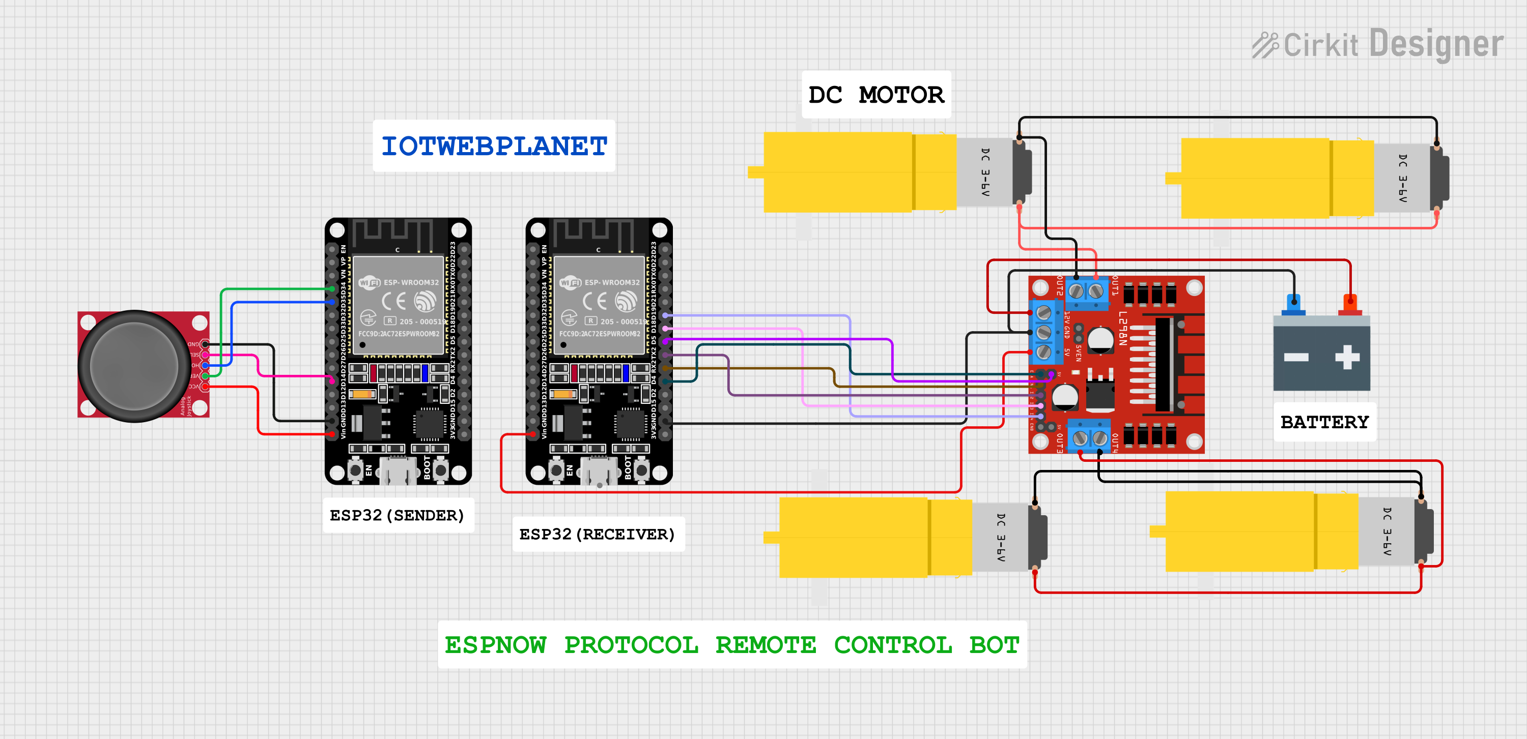
🤖 ESP32 Joystick Controlled Robot Using ESP-NOW Protocol & L298N Motor DriverWireless bot control w...
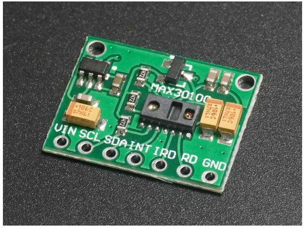
❤️ Heart Rate & SpO₂ Sensor (MAX30100/MAX30102)🔬 Pulse Sensor | SpO₂ Monitor | Wearable Health Tech...